

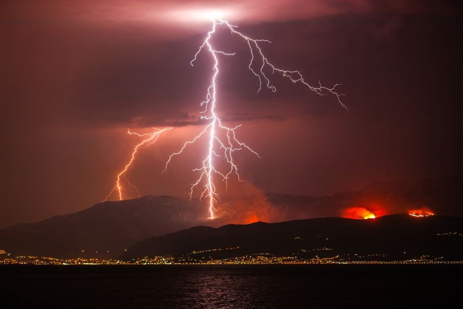
There is a point at which a wildfire stops being a fire and becomes something else entirely. It is not defined by acreage or flame height. It is not measured by evacuations or property loss. It happens when a fire generates so much heat that it punches through the troposphere and creates its own thunderstorm — a pyrocumulonimbus cloud that injects smoke into the stratosphere, spits lightning in every direction, and transforms the blaze from an ecological event into a meteorological one.
That threshold is being crossed more often every year.
In late July 2026, scientists monitoring the wildfire crisis in southwestern France observed something they had never seen before in the country: pyrocumulonimbus clouds towering above the flames. The fires in the Gironde region around Bordeaux had already forced tens of thousands of people to flee. Combined with blazes in Spain, more than 300,000 people have evacuated. French authorities warned that the fires would burn for many weeks and take months to fully extinguish, with another heatwave pushing temperatures toward 40 degrees Celsius (104 degrees Fahrenheit) forecast to compound the crisis.
What made the situation different from previous European fire seasons was not just the scale — it was that the fires had begun to generate their own climate system.
The Fire-Breathing Dragon
A pyrocumulonimbus cloud forms when the intense heat of a wildfire — often many times hotter than a typical forest fire — forces air to rise at extraordinary speed. This updraft carries smoke, ash, and enormous volumes of water vapor high into the atmosphere. As the air ascends and cools, the water vapor condenses into a cloud. If the fire is powerful enough and the atmosphere is sufficiently unstable, that cloud keeps growing until it becomes a full-fledged cumulonimbus — the same type of thunderstorm cloud that produces tornadoes and hailstorms.
NASA researchers who have studied the phenomenon described it as the fire-breathing dragon of clouds. The description is not hyperbole. A pyrocumulonimbus cloud does not merely accompany a fire; it becomes an active participant in the burn.
The dangers are fundamentally different from those of a conventional wildfire. The turbulent winds generated by the storm scatter embers in all directions, making fire behavior unpredictable and impossible to model with standard tools. Lightning bolts from the cloud itself strike the ground miles from the main fire front, igniting new blazes that flank firefighters from behind. The same storm that draws oxygen into the fire also creates downdrafts that spread flames laterally. Firefighters trained to read wind direction, anticipate fire spread, and establish containment lines suddenly find themselves facing a system that rewrites the rules of engagement every few minutes.
When Conventional Methods Fail
The practical consequence is stark: once a wildfire generates a pyrocumulonimbus event, it can no longer be fought with conventional methods. Aerial water and retardant drops become dangerous or impossible in the violent updrafts. Ground crews cannot predict where lightning will strike next. Embers travel distances that were previously considered impossible.
During Australia’s Black Summer fires of 2019-2020, pyrocumulonimbus events propelled embers as far as 30 kilometers (18.6 miles) ahead of the main fire front, roughly three times the distance that had been considered the worst-case standard for evacuation planning. Thirty-three people died. More than 11 million hectares burned. Entire towns were surrounded by fire fronts that appeared to come from multiple directions simultaneously, a behavior that satellite imagery later confirmed was driven by fire-generated storms.
In California in 2021, more than 7,300 wildfires burned 1 million hectares. Pyrocumulonimbus clouds towered 1.6 kilometers (1 mile) above the blazes, their anvil tops visible from space. Firefighters reported that the storms generated their own lightning, turning a single fire complex into a distributed network of ignition points.
The Feedback Loop
The most alarming characteristic of pyrocumulonimbus is the feedback loop it creates. Hotter fires produce more powerful clouds. Those clouds generate more lightning. That lightning starts more fires. And the smoke injected into the stratosphere can alter atmospheric chemistry in ways that may suppress rainfall, priming the landscape for even larger fires.
Research published in recent years has documented a clear global increase in pyrocumulonimbus events as fire seasons intensify. The trend tracks closely with rising average temperatures, earlier snowmelt, and prolonged drought in fire-prone regions. Scientists who have modeled the phenomenon predict that climate change will continue to increase the likelihood of pyrocumulonimbus events across the Mediterranean basin, the western United States, Australia, and parts of Canada and Siberia.
The conditions that produced the 2026 French fires fit this pattern precisely. Record-breaking European summer heatwaves, combined with minimal rainfall, created a landscape uniquely vulnerable to the kind of extreme fire behavior that generates pyrocumulonimbus. What was once a phenomenon confined to Australia and North America has now arrived in Europe.
A Different Kind of Fire
The difference between an ordinary wildfire and a fire that generates pyrocumulonimbus is not merely a matter of degree. It is a difference in kind. An ordinary fire burns through available fuel, spreads according to wind and topography, and eventually exhausts itself. A fire that has created its own weather has breached a threshold: it is no longer reacting to atmospheric conditions but generating them. It produces its own wind, its own lightning, and its own climate envelope that can sustain combustion even when external conditions might otherwise allow suppression.
This threshold is the one that France crossed in July 2026. The fires now burning in the Gironde have stopped being something that can be contained by conventional firefighting. They have become self-sustaining meteorological events that will burn until the fuel is exhausted, the climate shifts, or both.
French authorities have acknowledged that the fires will take months to extinguish. The admission reflects the new reality of fire management in a warming world. When a fire creates its own weather, you no longer fight the flames. You wait out the system.
The New Normal
The emergence of pyrocumulonimbus in Europe is part of a pattern scientists have tracked for years. Each fire season sets new records. Each new record produces behavior previously considered rare or impossible. The feedback loop operates on multiple levels: climate change makes fires more intense, intense fires generate pyrocumulonimbus, pyrocumulonimbus injects smoke into the stratosphere, and those particles can influence regional climate in ways that may suppress precipitation and extend fire seasons.
In 2026, that loop has reached France. Researchers who have studied the phenomenon note that once pyrocumulonimbus establishes a foothold in a region, it tends to recur. The conditions that made the 2026 fires possible — extreme heat, drought, an unstable atmosphere — are increasingly common across southern Europe. The record-breaking heatwave that followed, with temperatures forecast to reach 40 degrees Celsius (104 degrees Fahrenheit), suggests the season is far from over.
The practical implications for fire management are sobering. Evacuation planning must account for ember transport distances that can exceed 30 kilometers. Containment strategies cannot rely on the assumption that fire behavior will remain predictable for more than a few hours. Aerial operations become hazardous when updrafts can exceed the climb rate of aircraft. And the lightning generated by pyrocumulonimbus clouds means that even containing the main fire front does not prevent new ignitions downwind.
Beyond the Flames
The pyrocumulonimbus clouds over France in July 2026 represent more than an extreme weather event. They mark a threshold in the relationship between fire and climate. When a fire generates its own weather, it stops being a purely terrestrial phenomenon and becomes something that connects the ground to the stratosphere. The smoke pumped into the upper atmosphere by these storms can travel thousands of kilometers, affecting air quality and atmospheric chemistry across continents.
The fires now burning in southwestern France will eventually be extinguished, whether by a shift in weather or by exhausting the fuel that feeds them. But the conditions that produced them are not going away. The heatwaves that precede pyrocumulonimbus are arriving earlier, lasting longer, and reaching higher temperatures. The droughts that prime landscapes are becoming more severe. And the storms themselves leave their own imprint on the atmosphere.
The question that fire managers, meteorologists, and climate scientists now face is not whether pyrocumulonimbus will appear again in Europe. It has already appeared. The question is how quickly the feedback loop accelerates — and whether conventional fire management can adapt fast enough to keep pace with fires that have learned to make their own weather.