

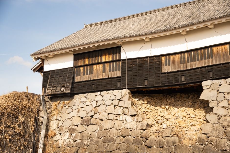
At 4:27 PM on July 28, 2026, the ground beneath Kumamoto City in southern Kyushu shook at a violence that Japan’s seismic scale cannot measure beyond its maximum. The Japan Meteorological Agency rated it Shindo 7. Within half an hour, the second floor of the Aeon Mall Kumamoto in Kashima Town collapsed after a gas explosion, killing two women and trapping at least nine others. A chimney at the Nippon Paper Industries Yatsushiro Mill toppled, killing two and trapping nine more workers. Kumamoto Castle, whose stone walls have stood since the early 17th century, saw sections crumble. More than 150,000 people fled to shelters. The Shinkansen bullet trains slammed to a halt. Roads buckled. Power failed for tens of thousands of homes.
Regardless of the metric used, this was a major disaster. But the most unsettling detail is not what the earthquake did. It is where it came from.
The Wrong Neighborhood
Approximately 90 percent of the world’s earthquakes occur at plate boundaries, where tectonic plates converge, diverge, or slide past one another. Japan sits on four converging plates and experiences roughly 1,500 quakes a year. The 2016 Kumamoto earthquake sequence, which killed 273 people, was a brutal lesson the region had already absorbed. The 2026 quake, however, did not originate at the Nankai Trough, the subduction zone where the Philippine Sea Plate dives beneath the Eurasian Plate some 100 kilometers (60 miles) offshore. It ruptured more than 100 kilometers inland on a shallow strike-slip fault only 10 kilometers (6 miles) deep. The rupture stayed firmly inside the continental crust. This was an intraplate earthquake, a class of seismic events that remains poorly understood because they are rare, unpredictable, and difficult to study.
The JMA officially named it the 2026 Kumamoto Earthquake and recorded it at M7.1 on the local magnitude scale. The United States Geological Survey, using moment magnitude, placed it at M6.8. That discrepancy is not a disagreement. It reflects two different measurement philosophies, and it tells seismologists something important about the nature of the rupture.
When Two Magnitudes Tell Different Stories
Local magnitude, the scale familiar to the public, measures the amplitude of ground shaking on seismographs. It was developed in the 1930s by Charles Richter and calibrated for Southern California. It works well for moderate, shallow earthquakes but saturates: for large ruptures, the amplitude of shaking stops growing even as total energy released keeps increasing. That is why the JMA’s M7.1 and the USGS’s M6.8 can both be correct. The JMA reading captures the shaking intensity that people felt and that the Aeon Mall could not withstand. The USGS moment magnitude, which measures the physical size of the fault rupture the area of slip multiplied by distance moved multiplied by rock rigidity captures the total energy budget. For large earthquakes, the USGS considers moment magnitude the more reliable estimate. The divergence tells seismologists that this was a moderate-energy rupture that generated intense shaking because of its shallowness, its proximity to populated areas, and the mechanics of intraplate faulting.
The Intraplate Mechanism
Intraplate earthquakes occur when stress generated at a distant plate boundary propagates through the interior of a tectonic plate and reactivates old faults that have been dormant for millions of years. The crust of the Eurasian Plate in southern Kyushu is traversed by ancient fracture zones from earlier tectonic deformation. Under normal circumstances, these faults lie quiet. But subduction is not a clean, straight-ahead process. The Philippine Sea Plate descends beneath Kyushu at an oblique angle, twisting the overriding plate as it goes. That twist transmits stress not only to the boundary but deep into the interior of the plate itself.
Jeffrey Park, a seismologist at Yale University, analyzed the fault motion and described it in terms of horizontal tearing. The fault did not slip vertically or horizontally in a clean, predictable direction. It moved in a way that suggested the plate was being torqued, pulled apart laterally as subduction forced it into a different geometry. According to Park, that tearing motion is characteristic of intraplate earthquakes in settings where the subduction zone runs at an oblique angle to the overriding plate. Stress accumulates in the interior, sometimes for centuries, until a dormant fault finally gives way.
This is what makes intraplate seismology both scientifically compelling and practically unnerving. Subduction zone earthquakes follow patterns that seismologists can model. Locked portions of a subduction interface can be identified. Recurrence intervals can be estimated. But intraplate earthquakes can rupture faults that no one knew were active, on structures showing no strain accumulation in satellite geodesy, in places far from expected danger zones.
Why No Tsunami
The earthquake did not generate a damaging tsunami because the rupture occurred entirely on land. Tsunamis require vertical displacement of the seafloor, typically from thrust faulting at subduction zones. A strike-slip fault deep inside continental crust displaces rock horizontally and almost no water. But inland earthquakes can still trigger tsunamis indirectly if shaking dislodges material that causes a submarine landslide. The 1998 Papua New Guinea tsunami, which killed more than 2,000 people, was triggered by a landslide, not the earthquake itself. Kyushu’s steep submarine slopes mean any significant inland earthquake carries a secondary tsunami risk.
The Kumamoto Context
The 2016 Kumamoto earthquake sequence, which ruptured the Futagawa and Hinagu fault zones through central Kyushu, were also intraplate events. They killed 273 people and triggered massive landslides. That the same region has been struck again only a decade later by another intraplate earthquake of comparable magnitude suggests the stress regime in southern Kyushu is more complex than plate-boundary models predict. The 2026 event also raises questions about whether the 2016 sequence relaxed or redistributed crustal stress. In some fault systems, a large earthquake reduces stress on nearby faults and creates a quiescent period. In others, stress transfer triggers earthquakes on adjacent segments years or decades later. Determining which pattern applies to Kyushu will require analysis of aftershock distributions, InSAR satellite data, and GPS strain measurements over the coming months.
What Intraplate Earthquakes Reveal
Intraplate earthquakes are scientifically more revealing than their subduction-zone cousins precisely because they are harder to explain. A subduction zone earthquake fits neatly into plate tectonic theory: two plates converge, stress builds at the locked interface, and the fault slips when stress exceeds frictional strength. The physics is complicated, but the geometry is straightforward. An intraplate earthquake requires seismologists to explain how stress traveled hundreds of kilometers through the interior of a plate without being absorbed or dissipated. It forces a reexamination of what constitutes a stable continental region. It challenges the assumption that distance from a plate boundary equals safety.
The geological community has invested heavily in monitoring plate boundaries, and for good reason, because that is where the vast majority of earthquakes happen. But the 10 percent that slip through the net can be disproportionately destructive precisely because they are unexpected. For Japan, a country engineered to withstand the worst the subduction zones can deliver, the intraplate earthquake remains the harder problem. The Shinkansen can detect a tremor and stop. The early warning network can give citizens seconds to take cover. Buildings can be reinforced to code. But if the fault is unknown, if stress accumulated silently for centuries on a structure that satellite imagery showed no sign of strain, then the entire early warning paradigm, which depends on knowing where danger will come from, is less effective.
The JMA’s official name for this event will appear in scientific literature for decades. But the real story is not in its name or magnitude. It is in the fact that a shallow rupture more than 100 kilometers from the nearest plate boundary turned a shopping mall into a tomb, toppled a castle, and sent 150,000 people into shelters. That should not have happened in a textbook model of plate tectonics. And the fact that it did happen is precisely why seismologists need to pay more attention to the earthquakes that are hardest to explain.
Sources: Live Science; Wikipedia (2026 Kumamoto earthquake); RNZ / Agence France-Presse; Japan Times; Indian Express; NHK; Channel News Asia.